Tuesday, December 30, 2014


C&D Canal Excavation - Mid-Thirties

Here’s an east view of the South Side excavation that widened the canal in the 1930s. In the distance you can see the pump house, the smoke stack, and other buildings. An older citizen told me that, at the time this widening was done, the Corps of Engineers wanted to remove these buildings. Certain citizens, however, made certain that the historic site was preserved and maintained as a museum. At right on the Causeway is the Masonic Hall, which was moved farther south because of the excavation. It was also turned 180 degrees to face the north. It was razed in the late 30s.

Tuesday, December 23, 2014

Tugboat and Old Pond


Old Canal with Tugboat and Pond


This is a steam tugboat heading west, approaching Chesapeake City. At left was a pond (part of Broad Creek) that ran up close to Birdy Battersby’s family house on East Canal Street. Morrison Watson told me a story about this pond that ran up to a bit beyond Bethel. He said that when he was a boy he lived in the town of Bethel, and he said that one time he had to row his skiff down this pond to North Chesapeake City to pick up a piece of furniture and row it back to Bethel.

Tuesday, December 16, 2014


Ericsson Line Steamer in Old Canal


The steamer, Penn, is seen here headed east in the “deep cut” (Summit area). Notice all the people assembled on the boat, evidence that these steamers were very popular. At right, on the north side, is the towpath, on which mules would pull barges and other vessels through the canal. It’s interesting to see how narrow the canal was in 1910; you could throw a stone across it.

Tuesday, December 9, 2014


1949 View of the Rt. 213 Bridge from the Ferry

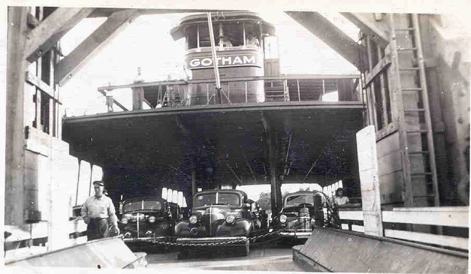
Here’s a west view of the completed bridge from the deck of the Gotham ferry. At left are Ralph Rees’ granary and several other buildings. Back Creek is in the distance with the extension of Schaefer’s wharf at right.

Tuesday, December 2, 2014

1950 Aerial View


1950 Aerial View of New Bridge with Divided Roadway of Old Lift Bridge at Left
I like this 1950 aerial view of Chesapeake City because it shows where the lift bridge used to cross from Lock Street to George Street. Many old buildings and streets can be seen, including Schaefer’s Restaurant, the Bayard House, the Shipwatch Inn, the old elementary/high school, etc. Notice City Dock (Rees’ Wharf) at far left. That area is now known as Pell Gardens.

Tuesday, November 25, 2014


Bridge Opening and Event Program, September 21, 1949


One: This is the dedication of the new bridge on Chesapeake City’s South Side. The school principal let us kids out of class to witness the ribbon-cutting ceremony. Wielding the scissors is Maryland’s governor Lane. I went up and down that bridge many times long before this dedication. Many people attended this event, including then mayor, Archie Crawford. He rode around in a convertible and waved at everybody. Two: This second image is the program for the ceremony that was passed out to everyone. Notice the small red, white and blue strip of ribbon that Governor Preston Lane snipped. I know that Birdy Battersby and Lee Colling obtained pieces of the ribbon as souvenirs.

Tuesday, November 18, 2014


Overhead Bridge Construction

Here’s our present overhead bridge under construction in about 1948. It was opened for traffic in the fall of 1949. I remember well watching the workers build this bridge from scratch as I sat in my eight-grade classroom. Instead of doing my class assignments I would gaze out the window at all the activity. I guess that’s why I spent the best three years of my life in that eight grade. I was about twelve at the time of this photo and I remember cycling up there to the end of the roadway and crawling to the edge to hang over and look down the smoke stacks of the tankers sailing under.

Tuesday, November 11, 2014

Bridge Destruction, Close-up View


Bridge Destruction, Close-up View
This is what I saw that afternoon after the ship hit our bridge. The Franz Klassen was a German ship and this was during the Second World War, thus some people suspected sabotage. This was not the case, however, because the ship had been taken over by the USA. Notice the derrick barge and, at left, the Ericsson Line building.

Tuesday, November 4, 2014


The Chesapeake City Lift Bridge Destruction
Here is a south view of the bridge damage by the tanker, Franz Klassen. The ship smashed into the south tower at 11:38 AM on Tuesday, July 28th, 1942. I was six years old and playing outside on our farm, which was about a quarter mile south of the bridge. I heard the crash and looked in and saw that the familiar bridge towers were not there. That evening after work my father took me in to see the destruction. He parked very close so we could see all the black steel lying across the ship’s bow. This aerial view shows parts of north and south Chesapeake City. Notice the old buildings on Lock Street and George Street. At left is the City Dock area (now Pell Gardens).

Tuesday, October 28, 2014

Helen Titter on the Lift Bridge


Canal bridges in the Chesapeake City area – circa 1907 – 1949: Teacher on the Lift Bridge
Posing here on the lift bridge is my remarkable sixth grade teacher, Helen Titter. She was supposed to have been an excellent swimmer. She used to meet a friend at Randalia by swimming all the way down Back Creek with the outgoing tide; she would visit long enough for the tide to change before catching it back home to Chesapeake City. She was a super teacher. I remember her spelling tests every Friday and the way she used to play the piano and have us sing. Every so often she would even check our teeth.

Tuesday, October 21, 2014

North view of the lift bridge


Canal bridges in the Chesapeake City area – circa 1907 – 1949: North View of Lift Bridge
This is a 1941 north view of the lift bridge. The small house there just left of the bridge was where the operators stayed to raise and lower the span. At far left is the Rio Theater and above the car is the front of Jumping Jim’s barber shop. At right is the sign for Shine Crawford’s Gulf station. I remember being here with my father in his ’41 Ford and waiting there by Jumping Jim’s for the span to lower so we could cross on our way to Elkton. My dad said: “Well, boy, you see those huge weights? When they start going up that’ll bring the road-way down, and when they reach the top we’ll be able to cross.”

Wednesday, October 15, 2014

Lift bridge, north west view


Canal bridges in the Chesapeake City area – circa 1907 – 1949: The Lift Bridge

Seated here on the porch of the Harriot Hotel (now the Bayard House) is John Breza, who helped to build the lift bridge he’s looking at. This is a North West view so you can just make out Schaefer’s store and restaurant in the distance. This porch has been renovated and is now enclosed. The photo is circa 1940.

Tuesday, October 7, 2014


Canal bridges in the Chesapeake City area – circa 1907 – 1949: The Lift Bridge
This is a south west view of the lift bridge that opened for traffic in 1926. Notice the heavy weight at right. There was one at left also (out of the picture). These weights balanced the structure somewhat, allowing less stress on the electric motor that powered the raising and lowering of the span. In the distance stands the Masonic Hall and above that on the span is the shack from which men used to operate the bridge. After a ship destroyed the St. Georges bridge in 1939 (killing Mr. Oaks and Mr. Quinn), our bridge was operated from a small building on the South Side.

Tuesday, September 30, 2014


The C&D Canal – circa 1907 – 1949: Ariel of Lift Bridge and Back Creek

This is a circa 1932 west view of the lowered lift bridge and Back Creek. At bottom right are the Corps of Engineers’ buildings at what was once the Causeway. In the distance at top left is the Chesapeake Boat Company and just above that is the Marine Construction wharf (now Capt. Dan’s and the site of the Delaware Responder). At left is what is now Pell Gardens and behind the right bridge tower is the old Schaefer’s restaurant.

Tuesday, September 23, 2014

Timber men on the log rafts


The C&D Canal – circa 1907 – 1949: Timber men on the white pine rafts

 
These are timber men balanced on rafts in the swampy area just south west of the Chesapeake City lock, circa 1912. Posing for the picture here are Elmer Watson, Mallory Toy, Harry Vance, James Watson, and Ed Reynolds. The men would break down these large, white pine rafts into smaller ones, making them narrow enough to fit through the lock. Mallory Toy was a colorful businessman who lived on Canal Street. I’ve been told that he built what is now the Shipwatch Inn.

Tuesday, September 16, 2014

Aerial of the Lift Bridge and City Dock


Canal bridges in the Chesapeake City area – circa 1907 – 1949: aerial of the Lift Bridge and City Dock

Here’s a terrific 1929 aerial view of parts of north and south Chesapeake City and the lift bridge. This bridge was opened for traffic in 1926, seven years after the Corps of Engineers bought the canal from the Canal Company in 1919. At left is what was left of Long Bridge, which was removed in the early thirties. You can see the Rio Theater in the distance towards the middle left and in the foreground what is left of the lock that had serviced the canal for many years. At right are Lock Street and the old Schaefer’s store, along with the large Ericsson Line building owned then by Roger Woolyhan. The swampy area just above the lift bridge was where my grandfather, Harper Hazel, worked as a timber man to break down the white pine rafts so the logs could fit through the three canal locks on their way to the Delaware River.

Tuesday, September 9, 2014

Rees' Wharf, circa 1915


Canal bridges in the Chesapeake City area – circa 1907 – 1949: Long Bridge, part 5
Here’s a view of South Chesapeake City’s Rees’ wharf in about 1915. Notice Long Bridge at left, Franklin Hall, the Apartments, the Cropper House, Rees’ granary, and the Bayard House. At about that time Albert Beiswanger had an ice cream parlor on the left just after you crossed the bridge. When I was a boy he had moved his store to George Street. The schooner (grain boat), Cara Dora, was owned by Walter Cooling’s grandfather, Capt. Zack Cooling.

Tuesday, September 2, 2014


Canal bridges in the Chesapeake City area – circa 1907 – 1949: Long Bridge, part 4
 
Here we see a southwest view of South Chesapeake City, with, at left, Long Bridge spanning across Back Creek. Notice the grain building just to the right of it. This building in this old picture was replaced by a newer one that I used to go under in the late forties and early fifties. In the distance is Franklin Hall, the Ohrel Building (once a tailor shop and existing now as one of the smallest bed and breakfasts in the country), and the Bayard House at right. The boys in town around that time (John Sager, Walter Cooling, Dick Titter and others) used to dive off Long Bridge and swim in this area of Back Creek. John Sager told me that Rube Hevalow operated this center pivot bridge by turning an iron crank, which took a good bit of energy. The boys would sometimes help him turn it when a vessel had to get through. John told me that one time Rube got mad at the boys for some reason and chased them away. Well, the boys came back later to get even and went under the bridge and put a rock in the gears to keep Rube from operating the bridge.

Thursday, August 28, 2014

Walking across the the Chesapeake City lock gate


Canal bridges in the Chesapeake City area – circa 1907 – 1949: Walking across the lock gate

Here are two men walking across the lock gate. My grandmother, Geneva Truss Hazel, used to take this short cut by walking across to the North Side like this to visit her sister, Lidia. She told me that she should not have done it because of the danger of falling into the lock. John Trush told me a story about when his father took him across this short cut when John was a little boy. He remembered being frightened when he looked down and saw how deep it was below.

Tuesday, August 19, 2014

Long Bridge, part 2


Canal bridges in the Chesapeake City area – circa 1907 – 1949: Long Bridge, part 2

Here you can see a horse and buggy coming off long bridge and headed for the South Side’s City Dock. In the distance the large building is the great Masonic Hall, and over to the far right side (south) is the Basin (now the location of the Chesapeake Inn). Straight ahead is the Causeway, which would eventually lead to Bethel Road. This area of the Causeway would be the place to be back in the early 1900s. There were many shops in the Masonic Hall and along the street. A store and an ice cream parlor were on the right side, and farther down was the old firehouse. It was moved to the South Side’s West Biddle Street and can be seen in its recently renovated condition. Several establishments were located in the Masonic Hall: a ladies clothing and hat shop, a second-floor barber shop, and on the third floor movies were shown. Cousin John Sager told me that when he was a boy he would go there to watch the movies and help his father, Jay, run the projector. In those times, if you wanted to visit the North Side, you’d have to walk or ride your horse across Long Bridge, go all the way down the Causeway, past the Corps of Engineers’ superintendent’s building, and finally make a left to cross the canal via High Bridge to Hemphill Street. You could also take a shortcut and cross by being brave enough to walk, tightrope style, across the lock gate to Lock Street. To do this you’d have to take a left before the Masonic Hall and walk down the “pathway to the lock.”

Tuesday, August 12, 2014

Long Bridge


Canal bridges in the Chesapeake City area – circa 1907 – 1949: Long Bridge
This pretty girl is Marion Wells. She’s sitting on the town’s fire bell, an iron ring the firemen would strike with a hammer to alert citizen volunteers of a fire. This is looking south, close to where the lock was located. Notice long bridge in the distance. It spanned Back Creek from the Causeway at left (now the Corps of Engineers’ area) to City Dock, AKA Rees’ Wharf, and now Pell Gardens at the area where Capt. Hazel moors the Miss Clare tour boat). At far right, on pilings, you can see Ralph Rees’ grain warehouse. At low tide, some of its old pilings can still be seen opposite the Canal Creamery. Franklin Hall is also visible at top right.

Tuesday, August 5, 2014

High Bridge – Part 4


Canal bridges in the Chesapeake City area – circa 1907 – 1949: High Bridge – Part 4

 
Here you are standing on High Bridge looking south, ready to walk the Causeway, cross Long Bridge, and enter South Chesapeake City. You can see at left the Corps of Engineers’ buildings and smoke stack in the distance. Notice the horse and the ship (headed west) waiting for the bridge to swing open so it can sail through. This wooden walkway extended pretty far and swung to the right until it hit the Causeway road.

Monday, July 28, 2014

Canal bridges in the Chesapeake City area


Canal bridges in the Chesapeake City area – circa 1907 – 1949: High Bridge – Part 3


Here’s an east view of the old High Bridge. You can see two old cars crossing over to Hemphill Street. An older Chesapeake City resident told me that one time, when his grandfather tried to drive a heavy horse and wagon across, the bridge collapsed into the canal. The building just to the right of the first car was the Woolley House.

Tuesday, July 22, 2014

Canal bridges in the Chesapeake City area


Canal bridges in the Chesapeake City area – circa 1907 – 1949: High Bridge – Part 2

 
Here’s a shot of the wooden swing bridge (High Bridge) looking north towards Chesapeake City’s Hemphill Street. This bridge spanning the narrow canal was activated by the tender engaging a small electric motor. The bridge pivoted from the North Side and swung towards the east. Note the bridge tender’s shack at left.

Tuesday, July 15, 2014

Canal Bridges


Canal bridges in the Chesapeake City area – circa 1907 – 1949: High Bridge

The photos and commentary for the next few weeks will be about the bridges that spanned the canal in the Chesapeake City area from about 1907 until 1949. This early post card shows the early, narrow canal, with the towpath on the right (North Side). The bridge in the distance is High Bridge, with the Corps of Engineers’ buildings off to the left (note the smoke stack for the large steam pump that brought the water from Back Creek to the locked canal. The bridge spanned Hemphill Street on the right with the Causeway on the left. The Causeway eventually led to Rees’ Wharf, AKA City Dock, which is now where the Miss Clare moors at Pell Gardens.

Tuesday, July 8, 2014

South Side Ferry View


Ferry View – South Side
Here’s a view of the South Side ferry slip. Note the Inn at the Canal (once Ralph Rees’ residence) at the far left on Bohemia Avenue. Flo Johnson Craig told me a story about riding in a car with her mother and uncle when she was a young girl. Her uncle was driving, and when they came off the ferry and made the sharp left turn towards home, the door flew open and she tumbled out onto the shoulder. She was not injured because she landed on a soft, grassy area.

Thursday, July 3, 2014

Ferry Slip Road – South Side


Ferry Slip Road – South Side
 

This is the Ferry Slip Road (circa 1944), the South Side approach to the ferry slip. In the early forties this road was put in especially for the ferry. There’s a story that, when they were working on this very marshy area, a bulldozer disappeared when it was sucked down into the quicksand. I don’t know if the story is true or not . . . but I hope it is! If you dig in the area and find it, let me know. You can see the small shack (at left) where folks could wait for the ferry in bad weather. On weekends in the summer months there was sometimes a long line of cars waiting for the ferry. The line would extend as far south as Randalia Road. Many resourceful kids (me included) would sell cold sodas and vegetables to people waiting in line for the ferry.

Tuesday, June 24, 2014

Gotham Ferry Close-up


The Gotham Ferry – 2
Here’s a close-up shot of the Gotham ferry. That could even be Capt. Ed in the pilot house at top. The man walking off is deckhand, Paul Rodeli. The woman at right coming off is unidentified (if anyone knows who she is let me know). Note the three passengers on the top deck. I rode this free ferry many, many times just for fun. Many folks in town did also. I’ve heard that it was written up somewhere (maybe in Guinness or Ripley’s) that, for its size, the Gotham provided the shortest ferry ride in the country, less than five minutes. If no trucks were loaded (center lane) the ferry could carry about twenty cars.

Tuesday, June 17, 2014

Gotham Ferry

The Gotham Ferry


In March of 1943 this large, car ferry was sent down from the New York City area to service the town. It took people, cars, and trucks across and back until the current bridge was opened in the fall of 1949. In the distance you can see the North Side ferry slip. With the strong wind and current it was sometimes very difficult to maneuver. Capt. Ed Sheridan was very skillful as its pilot. I can remember riding it when conditions were bad. It would come into the slip, bang into the pilings, and sort of slosh back and forth until it finally settled into the loading ramp. The man in the white shirt on the bow is Tweedy Ginn.

Tuesday, June 10, 2014

The Victory Ferry

The Victory Ferry


This is the Victory, a small boat used as a ferry before the Gotham arrived in March of 1943. The captain was Charles Cooling. The craft brought people back and forth across the canal after our lift bridge was destroyed at 11:38 am on July 28th, 1942. Here it is letting off school children from the North Side so they can attend our South Side school. It’s moored at City Dock, at the same location where Capt. Hazel ties the Miss Clare tour boat. The people (L to R) are Doris Long, Violet Hessey, Herb Edmonds, the Spear girls, and Miss Crowgey, a business teacher at Chesapeake City High School. I think the boy in the foreground is my classmate, Jack Wharton. In the background is the Mindy Building. At that time a Coast Guard unit was stationed in the area across the Basin.

Tuesday, June 3, 2014

The Wheat Boats

Wheat Boats at City Dock


These are the wheat boats at City Dock, also called Rees’ Wharf. These boats hauled grain through the canal to Baltimore, Philadelphia, and beyond. We’re looking southwest at what is now called Pell Gardens. I remember the large apartment building at center. Grason Stubbs, who used to swim right up next to the Gotham ferry as he tried to race it through the basin, lived in the apartments. At far right is Ralph Rees’ grain warehouse, located where the Canal Creamery is now. It was there when I was a boy. I used to go under the building to change into my bathing suit and come out to swim off City Dock. Hank Banks used to dive off from the top. Water Cooling, prominent Chesapeake City merchant, told me that when a boy he fell from the building, plunged into the water, and got his head stuck in the mud. He said that just his feet were sticking out of the water. His dad pulled him out just in time.

Tuesday, May 27, 2014

The tugboat, Startle

The Startle, a wooden, steam-driven tugboat

This is the most often-seen working tugboat in the Chesapeake City area of the C&D canal in the late 1800s and first half of the 1900s. You can tell it’s the Startle by the small horse statue at the cabin’s top. The Startle was one of five wooden, steam tugboats that serviced the canal. The other four were the Wister, the Cecil, the Ash, and the Roman. Pictures of all of these were given to me by Morrison Watson. To the left of this photo you can see where Joseph Schaefer’s ship’s chandlery was located. Now (2014) it’s the location of Schaefer’s Restaurant. Notice that the tug is pulling one of the wheat boats west through the lock into Back Creek. The large building in the distance is the Masonic Hall. The small building next to it is Groom’s Steele’s grain office. These buildings were located on the Causeway, a popular shopping area across the waterway from what is now Pell Gardens.

Tuesday, May 20, 2014

Steam vessel, Linda

The steam craft, Linda, owned by the Canal Company


This is the steam vessel, Linda, a small utility boat that was used by the canal company to take employees back and forth through the canal and to provide general service work. The young woman on the boat is Ellen Norris Savin, the daughter of toll-collector, Henry Norris. She would become the wife of Joe Savin and the matriarch of the prominent Savin family of Chesapeake City. The men aboard are (left to right): John Broadway, Bill Vaught, and Jake Hemphill. The boat is moored on the South Side, just east of the pump house.

Tuesday, May 13, 2014

The Wister, a Steam-driven Tugboat

Steam Tugboat, Wister, with Capt. Jacob Truss


Here is the Wister, a wooden, steam tugboat, with possibly my great, grandfather, Capt. Jacob Isaac Truss. Capt. Truss was the master of many steam vessels in the late 19th and early 20th centuries. The Wister was his last charge. After this he retired because of failing eyesight. Capt. Truss used to talk about seeing Civil War battles in the distance as he piloted his boat up the Potomac River.

Wednesday, May 7, 2014

Water Wheel

Water Wheel


Here’s the only picture, as far as I know, of the water wheel in action, actually pumping water through into the sluice. I used to think that the water was pumped out the front. From this we can see that it flowed from both sides of the pump house.

Pump House

Pump House and Water Wheel


Here’s the pump house that contains the big Cyprus water wheel. These building still stand, of course, as our museum. On the left is the building that served as the store room for the Corps of Engineers. The Corps employed many Chesapeake City residents. My father worked in the store room when I was a boy, and my mother took me along to pick him up at 4:30 every week day. The water would flow down this sluice and into the locked canal to replace the water that was lost when vessels locked through either on their way east through the canal or west into Back Creek. Men used to come here to fish with nets for herring or shad.

Tuesday, April 29, 2014

Steamer, Lord Baltimore

Chesapeake City Lock and Steamer, Lord Baltimore


Here’s the Ericsson Line steamer, Lord Baltimore, headed east into the Chesapeake City lock. Cousin, John Sager, told me a story about catching this steamer at Chesapeake City with his mother and steaming to the liner’s wharf at Pratt and Light streets in Baltimore. John remembered disembarking there and walking up the street to visit his aunt. A Chesapeake City lady told me that she once boarded this boat with her mother to sail to Philadelphia. She said they glided through the canal and entered the Delaware River when a storm caused huge breakers that rocked the boat, which caused her to fall out of her upper berth unto her mother who was in the lower one.

Tuesday, April 22, 2014

Locks on the C&D Canal – Joe Savin

Locks on the C&D Canal – Joe Savin


Here’s a photo of Joe Savin with his wife, Ellen. Ellen was the daughter of Henry Norris, the toll collector for the Canal Company. Joe and Ellen lived on the corner of 3rd and George Streets. Joe told me: “I was a carpenter on the canal and made 25 cents an hour. The carpenters under me made only 15 cents an hour.” Joe was mayor of Chesapeake City in 1929.

Locks on the C&D Canal

Locks on the C&D Canal


Here are some carpenters working on the Chesapeake City lock gate. There were three locks on the canal: Chesapeake City, St. Georges, and Delaware City. The one in Delaware City is still there for us to observe. The Corps of Engineer’s bought the canal from the Canal Company in 1919 and sometime in the 1920s they deepened and widened it. The locks became unnecessary after the deepening made the waterway a sea-level canal. One of the men seen here could be Chesapeake City’s Joe Savin. Joe was a master carpenter who maintained the three locks.

Tuesday, April 15, 2014

Mules on the Towpath


Old Chesapeake City and the C&D Canal


Note the mules on the towpath. Inset: Harry “Hat” Borger, former muleskinner who, in his youth, had walked the tow path as he led the mules that pulled the barges and other vessels through the narrow canal. Mr. Borger was the last mule driver to work the canal’s towpath. The towpath ran along the canal’s north side.

The C&D Canal


Old Chesapeake City and the C&D Canal


This is a schooner exiting the Chesapeake City lock from Back Creek, heading east.  Note mules ready to pull schooner through the narrow canal.